There are several things to consider when you are planning your hike on the Sunshine Coast Trail.
First, how long are you planning to hike for? You may choose to do the whole 180 kilometres, one of several shorter multi-day possibilities, or a day hike — there is something for every level of hiker, so be sure to check out all the possibilities.
No matter where you plan to go, make sure you are well prepared for your back country trip. Follow the three Ts—trip planning, training, and taking the essentials. AdventureSmart is a great resource to help you get informed before heading outdoors.
Next, be aware of current trail conditions. Our Facebook page is kept up-to-date with the latest work that is being done on the trail, so that hikers know what to expect. Because the Sunshine Coast Trail passes through some areas of working forest, it’s a good idea to arm yourself with information about sections that may be affected by operations before you go. In addition, sections of the trail pass through mountainous regions, and it’s good to be aware of the weather conditions you may encounter.
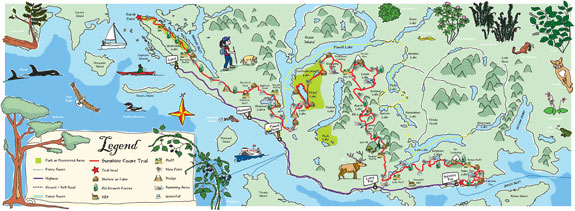
Maps are available here, and can be found in hard copy at Tourism Powell River on Joyce Avenue. Detailed maps of each trail section can be found in Eagle Walz’s Sunshine Coast Trail Guidebook.
Finally, for optimum enjoyment of this beautiful and challenging trail, check out our suggestions on what to bring to ensure that you are prepared for your SCT adventure!